
|
Strong City Vacation Rentals
|

|
|
|
|
|
Strong City Hotels and Resorts
|
|
|
| | | Hotels & Motels |
| Grand Central Hotel | 215 Broadway | Cottonwood Falls, KS | 1.7 mi. | (620) 273-6763 | | Comfort Inn | 2836 W 18th Ave | Emporia, KS | 17.1 mi. | (620) 342-9700 | | Holiday Inn Express Hotel & Suites | 2921 W 18TH Ave | Emporia, KS | 17.1 mi. | (620) 341-9393 | | Fairfield Inn | 2930 Eaglecrest Dr | Emporia, KS | 17.3 mi. | (620) 342-4445 | | Emporia Travelodge Conference Center | 2700 W 18TH St | Emporia, KS | 17.5 mi. | (620) 343-2200 | | Motel 6 | 2630 W 18TH Ave | Emporia, KS | 17.5 mi. | (620) 343-1240 | | Econo Lodge | 2511 W 18th St | Emporia, KS | 17.6 mi. | (620) 343-7750 | | Americas Best Value Inn | 2913 W Hwy 50 | Emporia, KS | 19.3 mi. | (620) 342-7567 | | Candlewood Suites Emporia | 2602 Candlewood Dr | Emporia, KS | 19.3 mi. | (620) 343-7756 | | Days Inn | 3032 W Hwy 50 | Emporia, KS | 19.3 mi. | (620) 342-1787 | | Quality Inn | 3021 W Hwy 50 | Emporia, KS | 19.3 mi. | (620) 342-3770 |
| | | Bed & Breakfast |
| Flint Hills Bed & Breakfast | 613 W Main St | Council Grove, KS | 18.3 mi. | (620) 767-6655 |

|
Strong City Weather & Climate
|

|
|
|
East-central Kansas has a humid sub-tropical climate. Over the course of a year, temperatures range from an average low of 15 degrees F. in January to an average high of nearly 93 degrees F. in July. The temperature falls below the freezing point an average of 188 days per year. Typically the first fall freeze occurs between the last week of September and the end of October, and the last spring freeze occurs between the first week of April and early May. The area receives 35 inches of precipitation per year, with the most in May and June. Snow depth of at least one inch occurs an average of 20 days per year. Severe weather is possible, in the form of thunderstorms and tornadoes. Thunderstorms may produce large hail and lightening.
|
| Month |
High Temp |
Low Temp |
Rainfall |
Ocean Temp |
| January |
39°F |
16°F |
0.97 in. |
- |
| February |
45°F |
21°F |
1.06 in. |
- |
| March |
55°F |
30°F |
2.82 in. |
- |
| April |
65°F |
41°F |
3.01 in. |
- |
| May |
75°F |
53°F |
4.90 in. |
- |
| June |
84°F |
62°F |
4.82 in. |
- |
| July |
90°F |
67°F |
4.40 in. |
- |
| August |
89°F |
65°F |
3.96 in. |
- |
| September |
81°F |
56°F |
3.42 in. |
- |
| October |
70°F |
43°F |
2.63 in. |
- |
| November |
54°F |
30°F |
2.60 in. |
- |
| December |
42°F |
20°F |
1.32 in. |
- |

|
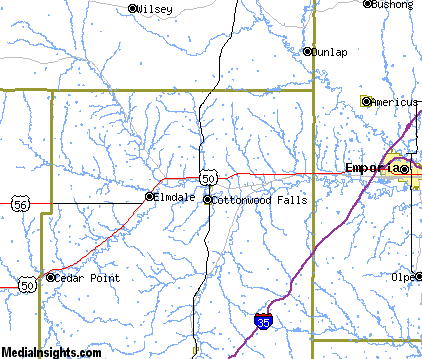
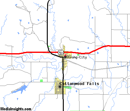
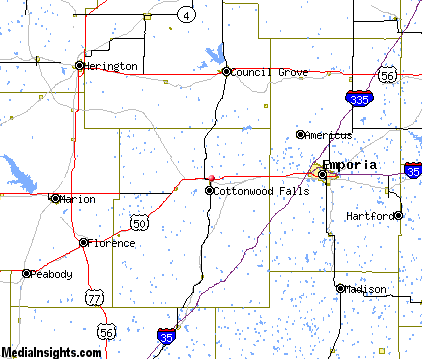
Strong City Map & Transportation
|

|
|
 |
|
|
| Click each thumbnail image to enlarge. |
 |
|
 |
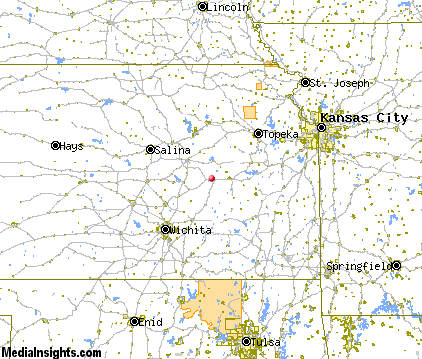 |
The closest airports in the area are the Newton City County airport (EWK) located about 46 miles west of Strong City in Newton, Kansas, the Manhattan Regional airport (MHK) located approximately 51 miles north of Strong City in Manhattan, Kansas, Forbes Field (FOE) located roughly 60 miles northeast of Strong City in Topeka, Kansas, the Beech Factory airport (BEC) located around 61 miles southwest of Strong City in Wichita, Kansas, and finally the Salina Municipal airport (SLN) located about 66 miles northwest of Strong City in Salina, Kansas.
|

|
Strong City Attractions
|

|
|
| | | Amusement and Theme Parks |
| Joyland | Wichita | KS | 65.3 mi. | |
| | | Water Parks |
| Golfland-Sunsplash Park | Olathe | KS | 98.6 mi. | | | Oceans of Fun | Kansas City | MO | 116.2 mi. | |
| | | Golf Courses |
| Emporia Municipal Golf Course | Emporia | KS | 19.3 mi. | | | Marion Country Club | Marion | KS | 25.9 mi. | | | Madison Golf Course | Madison | KS | 28.6 mi. | | | Herington Country Club | Herington | KS | 28.8 mi. | |
| | | State Parks |
| Geary County State Park | | KS | 38.9 mi. | |
| | | Museums |
| Kaw Mission State Historical Site | Council Grove | KS | 18.4 mi. | (History) | | Marianna Kistler Beach Museum of Art at Kansas State University | Manhattan | KS | 54.4 mi. | (Art) | | Goodnow House State Historic Site | Manhattan | KS | 54.4 mi. | (History) |
| | | Zoos and Aquariums |
| Emporia Zoo | Emporia | KS | 19.2 mi. | | | Sunset Zoological Park | Manhattan | KS | 54.4 mi. | | | Topeka Zoological Park | Topeka | KS | 64.6 mi. | | | Sedgwick County Zoo | Wichita | KS | 65.3 mi. | | | Hutchinson Zoo | Hutchinson | KS | 79.1 mi. | | | Kansas City Zoological Gardens | Kansas City | MO | 116.2 mi. | |
Notice a problem with the information on this page? Please notify us.
|
Disclaimer: We recommend you conduct your own research regarding all accomodations and attractions found on this website. The distances shown on this website are straight-line distances as the crow flies. The road distance may be considerably longer. You assume all liability for use of any information found on this website. No information is confirmed or warranted in any way. By using our services you agree to the terms and conditions of this disclaimer.
|
| We are the #1 site for your Kansas Vacation presenting Kansas vacation rentals, hotels, weather and map for each city. |
Kansas Vacation .com
©1997-2024 All Rights Reserved.
|
|